2D / 3D HORIZONTAL DIRECTIONAL DRILLING SOFTWARE

Bore planning software.
Auto topo to the next rod.

Draw the bore line. Add crossings. Bring in the topo. HDD Studio’s bore planning software turns your route into a 2D/3D pre-bore plan and rod schedule. Then take it to Dynamic Steer: actual pitch and depth in, recalculated targets for the rods ahead.

Full planning on Windows, macOS and iPad · public launch coming soon

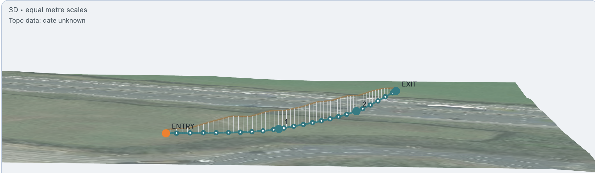
Real HDD Studio 3D drill shot and topographic profile with individual rod nodes, entry and exit
REAL APP SCREENSHOT · ROTATIONAL 3D VIEW IN HDD STUDIO
Topo profileRod-by-rod routeRotate in the app
HDD BORE PLANNER / TWO BIG ADVANTAGES

Get the ground in.
Keep the shot moving.

A clear plan starts the job. Revised field targets help the driller work with what the bore actually achieved.

01 / AUTOMATIC TOPOGRAPHY

Draw the line.
Bring in the topo.

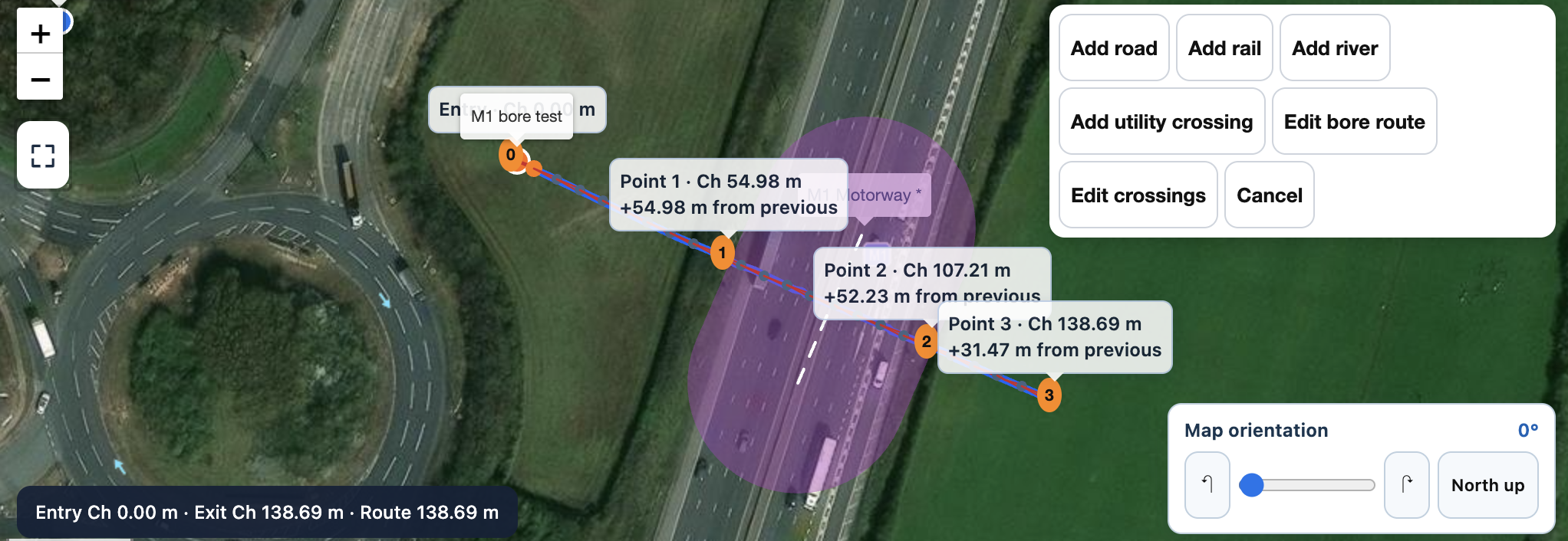
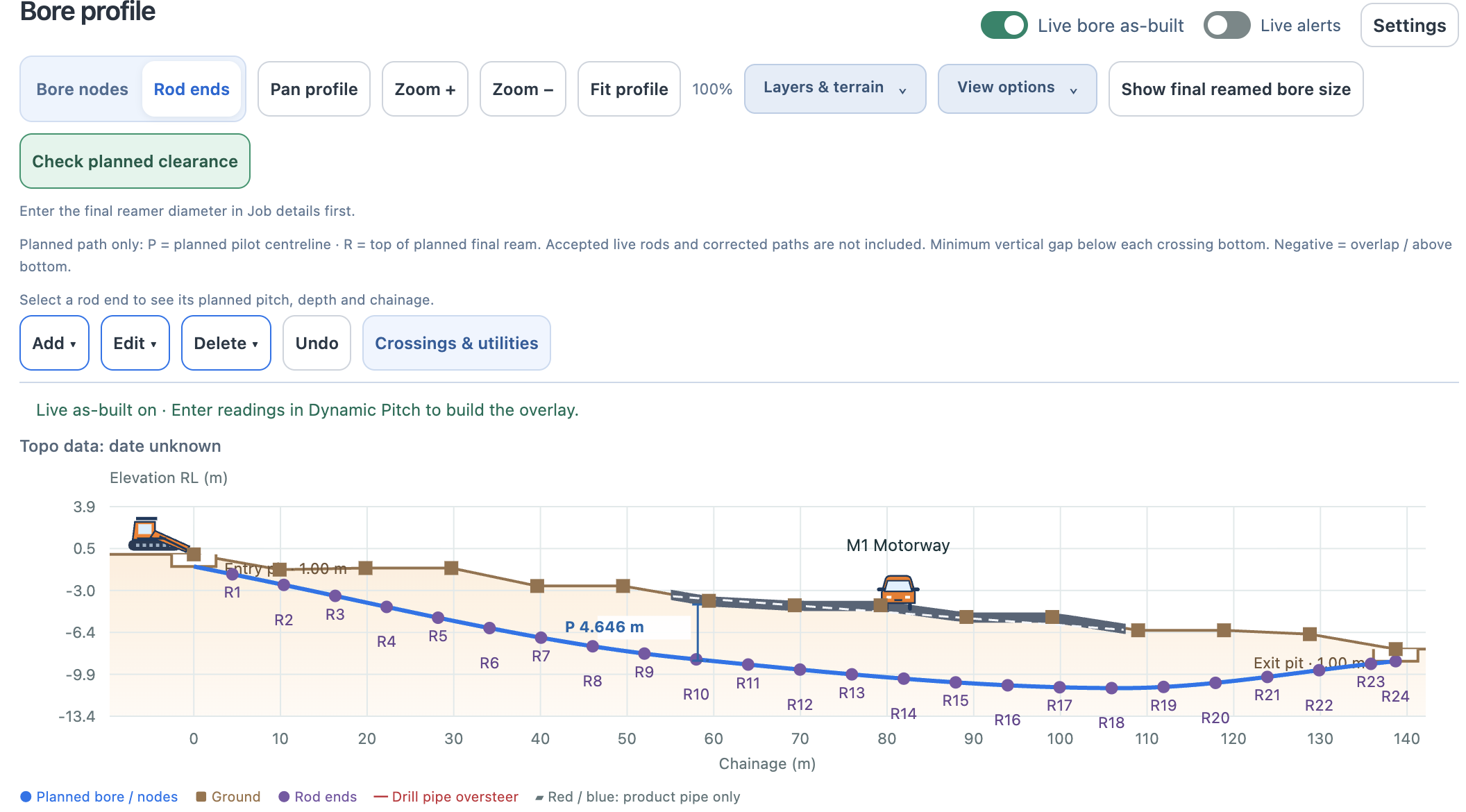
Start with a route on the map, rather than a blank profile. Draw the bore line and add your crossings. HDD Studio pulls in the route topography, so you can start shaping the shot around the ground.

Real HDD Studio bore planning software showing the automatic terrain profile, motorway crossing and planned rod endsREAL APP SCREENSHOT · AUTOMATIC TOPO AND BORE PROFILE

Automatic terrain is planning context, not survey-grade. Import supported CAD survey topography when surveyed source data is required, and verify site conditions.

Explore automatic topo ↗
02 / DYNAMIC PITCH CORRECTION

A good plan is
half the battle.

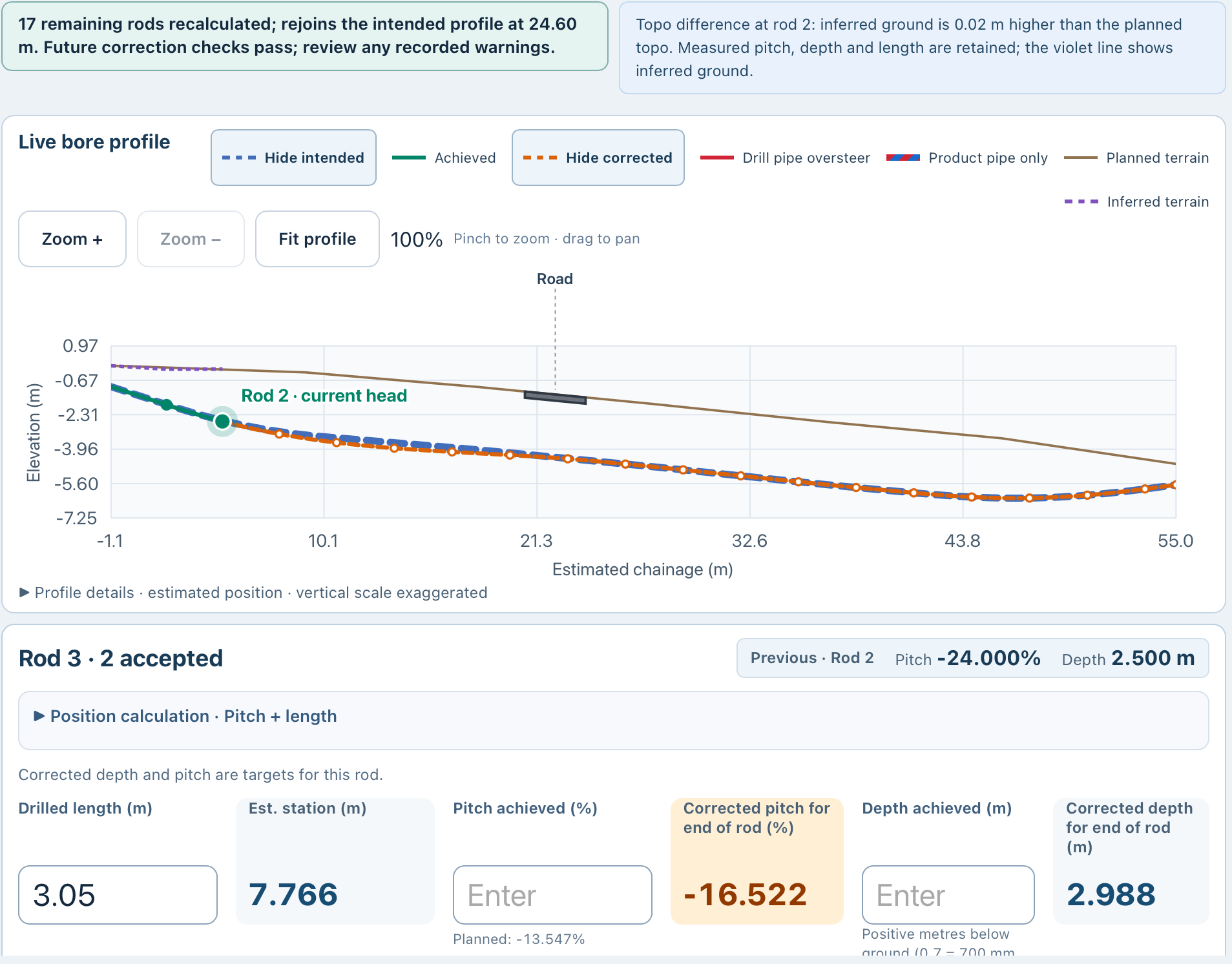
Missed the planned pitch at the end of a rod? Enter the actual pitch and depth in Dynamic Steer. It recalculates the route ahead and gives the driller revised targets, subject to feasible geometry and bend limits.

REAL ROD 3 EXAMPLE / PITCH TARGET
−13.547%−16.522%

Original plan → recalculated target · corrected depth 2.988 m

Real Dynamic Steer screenshot comparing planned pitch minus 13.547 percent with corrected target minus 16.522 percent and corrected depth 2.988 metresREAL TEST-JOB EXAMPLE · NOT A STEERING RECOMMENDATION

Vertical correction guidance does not control the rig or guarantee recovery from every deviation. The crew reviews the target and monitors left/right steering.

See dynamic pitch correction ↗
HDD BORE PLANNING / MAP → TOPO → ROD SCHEDULE

Draw it in.
Build the shot around it.

Bore planning software helps turn a proposed horizontal directional drilling route into a design the crew can review before drilling. HDD Studio brings the surface profile, crossings, bore geometry and planned rod values into one workspace.

Automatic topo makes the starting point easy: draw the drill path on the map and mark the crossings. Pull in the terrain, then refine the shot rather than rebuilding the same information by hand. See how automatic topography works →

01 / DRAW

Mark the route and crossings.

Set the proposed bore line. Add road, rail, river and utility crossings so the design has the site context from the start.

02 / DESIGN

Bring in the ground. Shape the bore.

Use automatic terrain or supported CAD survey topography. Refine entry, exit and cover, then inspect the shot in 2D and rotational 3D.

03 / REVIEW

Check the next level of detail.

Review rod lengths, pitch, cover, chainage and bend references. Carry the pre-bore plan into the rod schedule, report and Dynamic Steer workflow.

HDD Studio bore planner map with a drawn 138.69 metre route and marked motorway crossing
REAL APP SCREENSHOT · DRAW THE BORE LINE AND ADD CROSSINGS

Automatic terrain is preliminary planning context, not survey-grade data. Supported CAD survey import lets you bring in survey-grade source data; check the source, units and coordinate alignment. Verify utilities and site conditions before drilling.

A WORKSPACE FOR THE WHOLE JOB LIST

Start with the bigger picture.

See saved jobs on the HDD Studio project map, with pending, in-progress and completed statuses. Find the job, open the plan and work through the design.

See the real project map →
THE ROUTE IS ONLY THE START.

Fast to draw.
Room to think.

Start with the proposed route and automatic terrain, or import supported CAD survey topography. Set entry and exit, cover, setback and critical points. Edit the top-down route, then move between 2D and full rotational 3D viewing. Turn the drill shot and topo profile to inspect the geometry from different angles.

The rod-by-rod planner makes that geometry tangible. Inspect individual rods, review pitch and cover, and develop a pre-bore plan that the field crew can work through. Your equipment and fitted rods give the design its operating context.

01 / EQUIPMENT

Your rig. Your rods.

Set up the selected machine and fitted rods. Keep the plan independent of drill-rig brand, with equipment details appropriate to the job.

02 / GEOMETRY

Every bend has a context.

Review drill-pipe and product-pipe bend requirements, including lateral and compound bends. Identify where the route pushes selected limits.

03 / CROSSINGS

See what sits around it.

Bring roads, rail, rivers and utilities into the picture. Review crossing dimensions, clearance and the nominal final reamed-bore envelope.

04 / HANDOVER

A plan the crew can follow.

Carry the design into a rod schedule and pre-bore report. Transfer the bore file into Dynamic Steer for local field use.
THE PRE-BORE PLAN / ROD BY ROD

Review the shot.
Right down to the rod.

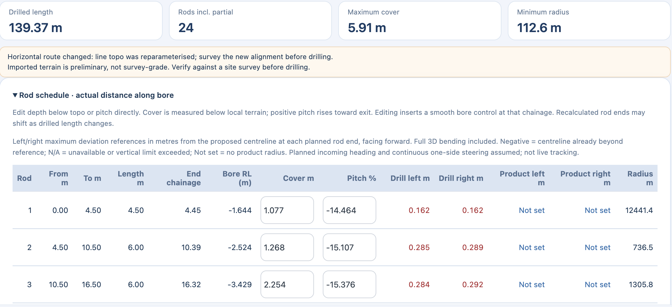
Go beyond the profile. This real pre-bore plan shows a drilled length of 139.37 m, 24 rods including the partial rod, maximum cover of 5.91 m and minimum radius of 112.6 m. Review each planned rod’s length, end chainage, bore elevation, cover, pitch and radius below. These are values from this example job, not limits for every bore.

HDD STUDIO / PRE-BORE ROD SCHEDULEREVIEW · EDIT · REFINE
Real HDD Studio pre-bore rod schedule showing summary values and planned rod length, end chainage, elevation, editable cover and pitch, drill and product steering references, and radius
REAL APP SCREENSHOT · PLANNED ROD SCHEDULEEnlarge screenshot ↗

Read the plan.

Review the overall length, rod count, maximum cover and minimum radius, then work through the detail at each planned rod end.

Refine it directly.

Edit depth below the topo or pitch in the schedule. The bore is recalculated, so you can review how the rod positions and geometry change.

Keep limits in view.

Review left/right drill and product steering references alongside the planned radius, with full 3D bending included.

Steering references are planning aids, not live tracking. They depend on the planned incoming heading and assumed continuous one-side steering. Product references require a product radius; unavailable or exceeded limits must be reviewed. Automatic terrain remains preliminary and should be verified against a suitable site survey.

Carry the detail into your reporting →
FROM THE MAP TO THE FIRST ROD

Keep the detail.
Lose the repeated setup.

Automatic topo brings the background in quickly. The planner gives you the tools to refine the route. Dynamic Steer carries the plan into the field, while reporting brings the record together.

Design checks support engineering judgement. Sampled steering guides are planning aids; the nominal reamed envelope does not model overcut or ground movement. Verify survey data, utilities and site conditions.

See the next step in the field →
THE PRACTICAL DETAILS

Before you start.

What is HDD bore planning software?

An HDD bore planner is bore planning software for developing a horizontal directional drilling route before drilling. HDD Studio combines terrain, crossings, 2D/3D bore geometry and a rod-by-rod schedule so the proposed shot can be reviewed in context.

How do I get topography into the bore plan?

Draw the bore line and crossings on the map, then pull in automatic route topography. For a surveyed design, import supported CAD topography from a suitable survey. Automatic terrain is not survey-grade and must be verified before drilling.

How does the bore plan connect to Dynamic Steer?

Transfer the bore file into Dynamic Steer for local field use. Enter actual rod pitch and depth to recalculate targets for the route ahead, subject to feasible geometry and bend limits. Connected plan publishing and revisions are in private testing; public launch is coming soon.

Is HDD Studio tied to Ditch Witch, Vermeer or Tracto rigs?

The planning workflow is brand-agnostic. Set up the machine, rods and relevant limits for the job. HDD Studio is independent and is not affiliated with or endorsed by those manufacturers; a brand reference does not imply a direct hardware connection.

What goes into the pre-bore report?

The reporting workflow brings the job summary, bore profile, crossing information and rod schedule together. Relevant detail includes rod pitch and cover, crossing clearances, drill/product steering limits and review records.

Can the bore planner help if the achieved pitch differs from the plan?

The pre-bore plan provides the starting reference. In the Dynamic Steer field app, enter the actual rod pitch and depth. Dynamic pitch correction recalculates targets for the remaining route, subject to feasible geometry and bend limits. It supports the driller’s decisions; it does not automatically steer the rig or guarantee a recoverable path.

Are cloud plan updates publicly available?

Public launch is coming soon. Shared company jobs, office-to-field publishing, live accepted-rod updates and plan revisions are in private testing. Local bore-file transfer is available for the standalone workflow.

PUBLIC LAUNCH COMING SOON

Your next bore.
A better starting point.

Register for launch information and choose whether to receive news of subscription discounts.

Register your interest ↗Talk to HDD Studio →